 |
| Fissure of main sinter terrace at Steamboat Springs |
On Saturday October 12, 2019, I joined a guided trip around the
Steamboat Spring geothermal area. The tour was organized by the NV Bureau of Mines Mines and Geology. Out tour guide, a geologist of Ormat Technologies, Inc., which operates the plant, did an excellent job in explaining everything from geothermal energy production, local geology, mineralogy and on-site plant life.
Traveling around between Reno and Carson City or over to Incline Village, you may have seen the hilly area with its facilities and occasional
puffs of steam—just south of Mt. Rose Highway near the Summit Mall and west of old US 395. The new I-395 is traversing the geothermal grounds. You need to be part of a designated tour to enter the area.
 |
| What's in the fissure? What may come out? |
Steamboat Springs is a small
volcanic field that lies on several
rhyolitic domes named the
Steamboat Hills Rhyolite [1]. The geothermal activity of the area includes
hot springs,
steam vents and
fumaroles.
Geyser eruptions have been observed in the past [2]. The geology of this thermal area has been studied in depth (see, for example, the list of references given in [1] and the Geological Survey report [3]).
 |
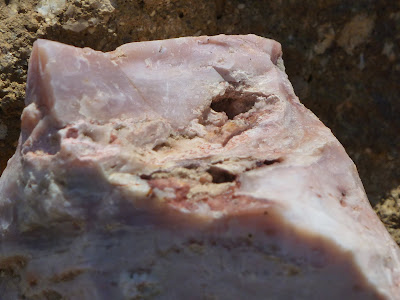
| Chalcedonic quartz found at high terrace |
The supply of hot water at Steamboat Springs originates as Carson Range snowmelt runoff seeping through porous rock and fractures down to the granite bedrock. It is thought to be heated above a magma chamber, from where it then rises rapidly in a plume-like form along other fractures. Production of electricity at Steamboat Springs began in 1984.
Our trip included a visit of the
power plant and hands-on exploration of the
main sinter terrace, the
high terrace (
silica hill) and the
silica pit.
 |
| Dwarf Jeffrey pines holding on to a steep, white slope of silica pit |
While browsing the main sinter terrace, two elderly lady participants mentioned how they were playing in the warm water on the terrace, before the area was managed by Ormat. Today, there is no visible outflow of hot water, but we saw some steam coming out from what we were told had been an active fumarole along one of the fissures.
Two open, parallel, north-south directed fissures are the most striking features that you will immediately notice when arriving at the main sinter terrace. You may not notice the
rare steamboat buckwheat plants growing on the main terrace and nearby; but your tour guide will point them out to you and make sure you are not going to step on any individual of this interesting species that found its niche in a challenging sinter-and-soil environment.
 |
| Yellow hard hats were required while touring the power plant |
How to plan a visit to the Steamboat Springs geothermal area
References
[1]
Site descriptions by the University of Nevada, Reno, and the Nevada Bureau of Mines and Geology. Link:
data.nbmg.unr.edu/Public/Geothermal/SiteDescriptions/Reno.pdf.
[2] Dave Coppedge:
Steamboat Springs' lost geysir. Link:
www.flickr.com/photos/psa104/8445144069.
[3] D. White, G. A. Thompson and C. H. Sandberg:
Rocks, Structure, and Geologic History of Steamboat Springs Thermal Area, Washoe County, Nevada. Geological Survey Professional Paper 458-B, United States Government Printing Office, Washington, 1964. Link:
pubs.usgs.gov/pp/0458b/report.pdf.


